
Stream Buffers and Setbacks
How it Works
and Stream Corridor Protection
A stream buffer (also known as a riparian buffer) is a defined area along a watercourse that is protected from development for the purpose of preserving the natural benefits of riparian ecosystems and reducing hazards risks of such areas (though a mapped Fluvial Hazard Zone would be a better tool for assessing the hazard and risk in these areas). They are implemented in a similar manner and often in concert with buffers for wetlands and other sensitive areas such as tundra, steep slopes, and wildlife habitat. They are intended to protect the many functions (hydrologic, biological, ecological, aesthetic, recreational, and educational) that riparian areas provide to communities.
A stream setback is the minimum distance that a development must maintain between its boundaries and a riparian area to protect a buffer zone. Standard setback distances often range from 50 to 100 feet from the stream or river, but can vary based on the specific riparian zone. Both stream buffers and setbacks are used to limit or prohibit certain types (or all) development within them. They can differ from traditional floodplain ordinances – which typically focus on minimizing property damage by restricting development in a floodplain – by instituting additional restoration and ecological protection requirements within the buffer. In some cases, restoration requirements – such as planting appropriate vegetation – are included as a condition for obtaining a development permit.
Stream buffers and setbacks function by limiting the amount of development adjacent to riparian and wetland zones to reduce exposure to flood risk and preserve the capacity of the buffer to minimize hazards through ecological processes.
Stream buffers and setbacks function by limiting the amount of development adjacent to riparian and wetland zones to reduce exposure to bank erosion and preserve some of the capacity of the buffer to minimize hazards through ecological processes. Additionally, such requirements can work by discouraging certain types of uses in these areas that could negatively impact water quality.
Stream buffers or stream setbacks, when used as a means to reduce flood damages, assume that streambank erosion is the only hazard in the corridor. While streambank erosion may be the dominant hazard in certain areas, in most locations numerous other fluvial hazards exist including sedimentation and debris deposition, channel avulsions, and the development of flood chutes and these additional hazards are not captured by a buffer, but rather a different tool: Fluvial Hazard Zone mapping. Buffers assume channel erosion will only progress within a certain distance from the existing channel and this assumption is often a failure to assess and understand the interactions between water, geology, vegetation and human interventions in the stream corridor. While stream buffers and/or setbacks may be useful for protecting water quality and riparian habitats, establishment and management of Fluvial Hazard Zones will have similar or better environmental and water quality benefits as well as better outcomes for reducing long-term flood risk.
Stream buffers and setbacks are implemented and enforced through local ordinance or codes. Generally, local requirements may be adopted either as part of a land use or zoning code, as stand-alone ordinances, or as part of other regulations (such as stormwater management regulations). Local governments take many different approaches to implementing stream buffers and setbacks. Some communities have fixed-width, non-varying setbacks for a variety of riparian areas (e.g., a 100-foot setback applies to all waterways). Other communities may adopt sliding-scale approaches with variable standards, based on different stream sizes and classifications and different types of land uses (e.g., certain intensive uses must be set back 100 feet, while less-intensive use must be set back 20 feet).
In addition, communities are authorized by statute to include provisions “establishing, regulating, and limiting such uses on or along any storm or floodwater runoff channel or basin as such storm or floodwater runoff channel or basin has been designated and approved by the Colorado Water Conservation Board (CWCB) in order to lessen or avoid the hazards to persons and damage to property resulting from the accumulation of storm or floodwaters.” (C.R.S. § 30-28-111(1) and §31-23-301(1))
Pitkin County enforces minimum fixed-width buffers of 100 feet from the high water line of a riparian or wetland area. Setback requirements can be reduced up to 50 feet if the applicant proves that a reduced buffer will not degrade water quality, contribute to stream bank erosion, or negatively impact the riparian or wetland habitat. Setback requirements in addition to the standard 100 feet may be required based on slope, soil, stream bank stability, proposed use of the property, 100-year flood zone boundaries, existing vegetation, flood and stormwater retention needs, or the presence of fish habitat or recreational amenities. In some cases, the Board of County Commissioners will determine that a setback of 150 feet or more is in the best interest of public health, safety, and welfare.
Some types of developments are exempt from setback requirements, like bridges, roads, trails, utilities, irrigation equipment, and flood control devices, if it is demonstrated that there is no alternative placement and disturbance to the buffer zone will be appropriately mitigated. In general, Pitkin County requires damage to a buffer area from any development to be adequately mitigated through re-grading and re-vegetation.
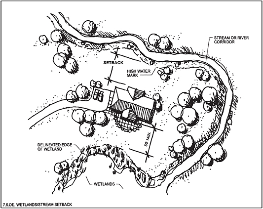
Estes Park, and the surrounding Estes Valley, requires stream setbacks for all new development with the exception of some agricultural, maintenance, utility, habitat restoration, flood control, and recreational activities. Setback requirements in Estes Park depend on the type of waterway and the zoning classification of the area. The boundaries of streams and rivers from which the setbacks are measured are typically determined using the annual high water mark, defined banks, or the “thread” of the stream (the deepest groove or low water mark), depending on discernibility.
All buildings and accessory structures near a stream corridor, with the exception of those in the Commercial District zone, must be set back at least 30 feet, and those near a river corridor must be set back at least 50 feet. Parking lots must be set back 50 feet from both stream and river corridors. Within the Commercial District zone, structures must be set back by 20 feet from stream and river corridors, and parking lots must be set back by 12 feet. In most cases these requirements result in new construction being located outside of special flood hazard areas, and are credited with saving numerous structures from damage during the September 2013 flood event.
The City of Fort Collins determines the width of buffer zones based on the presence of ecological features, specific stream corridors, or the size of the wetland. Buffer widths range from 50 feet for isolated patches of riparian forest to between 100 and 300 feet for streams. An Ecological Characterization Study is required if a development site is within 500 feet of a natural feature, including wetland boundaries, and the top of bank, shoreline, and high water measurements of a perennial stream. This study informs the establishment of buffer zones to be included on project plans for development.
San Miguel County has fixed-width buffers of 100 feet. Any development within a buffer zone requires a Wetland Special Use Permit, which can be obtained if the development meets discretionary review standards. The land use code dictates restoration requirements for developers to restore wetland and riparian buffers to a functional condition if the ecosystem is altered or disturbed.
Benefits of implementing stream buffers and setbacks include:
- Helps to preserve natural and beneficial functions of the floodplain.
- Protects the water course from the impacts of neighboring and upstream land uses.
- Helps reduce flood vulnerability both at the site as well as the surrounding area and downstream.
- Promotes habitat preservation of aquatic and adjacent riparian environments.
- Helps preserve water quality by limiting proximity of potential pollutants.
- Facilitates stream bank stability and reduces erosion potential.
Some of the challenges associated with stream buffer and setback regulations include:
- Political will and community support is required to implement limitations on development location.
- Inability to implement along corridors where properties are already developed unless the property is destroyed or redeveloped.
Hazards Addressed
Models and Commentary
Stream Buffers and Setbacks Model and Commentary
Key Facts
- Administrative Capacity: Experienced planners with city or county attorney to write regulations and normal capability to administer the standards once adopted
- Mapping: Mapping is strongly recommended. Can be coupled with open space, FEMA or floodplain overlay, or regular land use mapping
- Regulatory Requirements: Local regulations are generally adopted as part of land use or zoning codes or as part of other regulations (such as stormwater management regulations)
- Maintenance: Minimal. Generally part of development review once regulations are adopted
- Adoption Required: Yes
- Statutory Reference: General land use authority is found in C.R.S. § 29-20-101. Colorado’s “1041 Regulations” further describe the administration of natural hazard areas as they pertain to floodplains. 1041 Regulations are addressed in a separate model
- Associated Costs: Ordinance development or amendment costs and staff time to review development for compliance with regulations and monitor for enforcement
Additional Resources
Examples of the Tool
- City of Aspen Environmentally Sensitive Areas and Stream Margin Review Land Use Code, Part 400, and Section 26.435.040
- Pitkin County River and Stream Corridors and Wetlands Pitkin County Land Use Code, Section 7-20-80
- City of Boulder Stream, Wetland, and Water Body Regulations
- Town of Estes Park and Estes Valley Wetlands and Stream Corridor Protection Estes Valley Development Code, Section 7.6
- City of Fort Collins Natural Habits and Features and Establishment of Buffer Zones Land Use Code, Division 3.4, and Section 3.4.1.E
- San Miguel County Wetland Areas Land Use Code, Section 5-22