Parks and Open Space Plan
How It Works
Parks and open space plans are intended to guide a systematic approach for communities to provide and preserve parks, undeveloped lands, and recreation services for the public good. While all comprehensive plans adopted by Colorado communities are required to include a recreation and tourism element, many choose to develop a separate, complementary parks and open space plan that includes more detailed information. Parks and open space resources within a community may include natural, scenic, cultural, historic, and recreational features or amenities. While such resources often are dispersed, communities increasingly are attempting to build interconnected park and open space systems linked by trails, greenways, or other public corridors.
The development of a parks and open space plan is often spurred by the desire to enhance public functions such as environmental protection, outdoor recreation, and growth management, thus shaping future development patterns to meet community needs while preserving areas in their natural state. Parks and open spaces often overlap with critically sensitive or hazardous areas such as floodplains, steep slopes, or areas prone to wildfire. This provides communities with unique opportunities to pursue the mitigation of natural hazards by avoiding development in these areas jointly with other community goals through the implementation of their parks and open space plan. Multi-benefit solutions have the additional advantage of being more likely to be supported by elected officials and the community at-large, and could even help leverage outside technical or non-traditional funding assistance.
Some common examples of how parks and open space plans dovetail with hazard mitigation goals include:
Mitigation of flood hazards. Parks and lands preserved as open space play a critical role in flood risk reduction. Prohibiting development in known flood hazard areas is the only sure method to minimize future flood losses with little to no residual risk. This strategy is often employed along rivers and streams that are also very appealing areas for:
- Creating parks and recreational assets such as picnic areas, hiking trails, and bicycle paths;
- Providing riparian buffers and other green infrastructure assets for improving water quality and stormwater management; and
- Preserving or enhancing the natural and beneficial functions of floodplains.
The acquisition and demolition or relocation of existing flood-prone structures is also a common technique for communities seeking to reduce flood risk and synergize the efforts with other compatible goals as expressed in the parks and open space plan. In addition, the use of parks and other undeveloped lands for stormwater detention or retention practices can serve not only as a flood mitigation technique but also as a means to conserve water, improve water quality, increase biodiversity, or enhance aesthetics.
- Mitigation of geologic and other hazards. Many communities have adopted plans for parks and open space to support the acquisition or conservation of lands that also happen to be in hazardous areas, such as mountainous locations that are subject to landslides, avalanches, or wildfires. These areas are preserved not only for their aesthetic and ecological value, but also to support economic development opportunities that are associated with park and recreational amenities. Parks and open space plans are ideally suited for promoting synergies between these values and linking the added benefits of public safety by discouraging the development of lands facing dangerous geologic conditions or wildfire threats.
Much like any other planning document, parks and open space plans vary widely in terms of format, organization, and level of detail, based on the goals of the jurisdiction and the resources available to support the planning effort. Most parks and open space plans contain the following components, or some variation:
- Inventory of assets – What is the current total amount of parks, open spaces, trails, and recreation areas and facilities? Where are they located? Where are there gaps in the system? Are assets located in hazard areas?
- Policies – How should the community address issues related to parks and open space? Should additional investments and land acquisitions occur outside of hazard areas? Is increased maintenance a priority? Should the community consider sharing resources?
- Priorities and recommendations – What are the specific steps a community can take to address a stated issue? Are there gaps in the system that should be treated as priorities? Should areas outside known hazard areas be given higher priority than others?
These elements are described below, including example policy language to integrate hazard mitigation, where applicable.
Inventory of Park and Open Space Assets

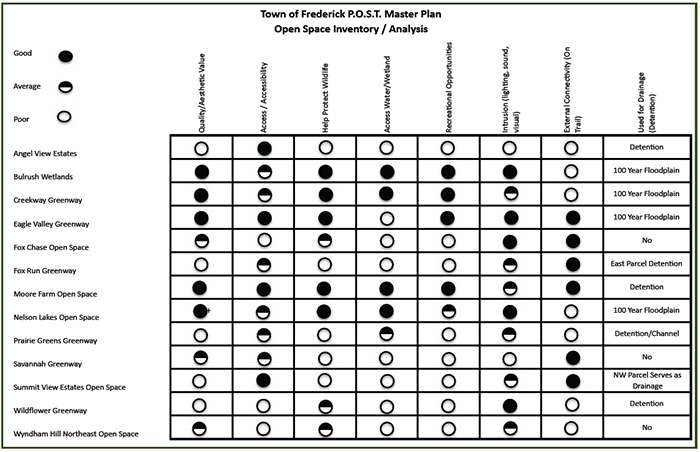
open spaces are used for drainage and detention. Source - Town of Frederick
When identifying existing parks, open space, trails, and recreation areas, it is important to recognize the synergies between conservation of those areas and hazard mitigation.
The Town of Frederick’s Open Space Inventory includes a table that identifies which open spaces and greenways are used for drainage or detention. The far right column on the table below indicates uses for drainage and detention.
The Town of Frederick’s Open Space Inventory Analysis indicates which open spaces are used for drainage and detention. Source - Town of Frederick The Town of Frederick’s Open Space Inventory Analysis indicates which open spaces are used for drainage and detention. Source - Town of Frederick
The Colorado Springs Park System Master Plan dedicates an entire section of its inventory of park/open space assets to recognizing the impacts of natural events such as drought, fire, and flood. The plan states, for example:
“Drought can have significant impacts on parks, open space, and recreation sites:
- Increased wind erosion of soils and poor soil quality
- Forest and vegetation quality degradation
- Increased risk of wildfires
- Loss of wetlands and aquatic habitats for wildlife
- Loss of water-related recreation activities
- Need for increased watering of turf and plant materials to prevent loss”

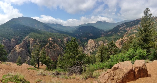
CO. Source - Miguel Vieira
Developing comprehensive maps is an important tool for summarizing and communicating the results of the park and open space inventory. Maps should show the inventory of existing assets described above, along with providing analysis (e.g., access to parks/open space from residential neighborhoods, identification of gaps in the overall parks and open space system). Maps will also help identify future projects or acquisition areas. Natural hazard areas should be included in this mapping process, recognizing the linkages between conservation of open space and risk reduction to property and life. Areas to potentially identify in plan maps include:
- Steep slopes
- Flood hazard areas
- Wildland-urban interface
- Subsidence zones
- Avalanche paths
- Unstable soils
- Other geologic hazard areas
Policies
Parks and open space plans use the inventory of assets and identification of issues and gaps in service to develop policies to help achieve the goals of the plan. Those policies can include statements related to reducing risk and hazard mitigation. Some examples of policies that address hazard areas include:
- Encourage the use of floodplains and major drainage facilities for recreational use, open space, and other appropriate uses that preserve the natural environment and minimize the potential for property damage.
- Work with experts to ensure there is an adequate buffer between development and natural areas, water bodies, wetlands, and floodplains.
- Maintain adequate buffers through open space preservation to allow high-hazard landscapes to function in a natural way with minimal human intervention and modification.
- Strengthen safety and security in the community’s parks, open space, and recreation areas by addressing flood, fire, drought, and other hazard issues.
- Design park facilities to preserve natural features that help control stormwater, and minimize the introduction of new structural features and impervious surfaces.
Priorities and Recommendations
Much like a comprehensive plan, the parks and open space plan typically establishes recommendations and strategies to achieve the stated policies and goals of the plan, such as:
- Review floodplain regulations and revise, as appropriate, to encourage recreational and open space uses within floodplains.
- Review floodplain regulations to ensure they sufficiently limit the amount a floodplain can be modified when considering current and future parks, open spaces, and recreation areas.
- Prioritize acquisition of riparian corridors for open space preservation to achieve multiple benefits (e.g., trail connectivity, stormwater management, habitat preservation, and recreation).
- For [specific park or open space], provide a trail surface that can stand up to intermittent flooding during high water events in an effort to reduce ongoing maintenance requirements.
- For steep slopes, allow adequate separation from developed landscapes.
- For fire zones, provide demarcation or buffer zones between development landscapes and natural forests.
- Land not suitable for development or passive recreation within new development proposals due to steep slopes, poor soils, floodplain areas, or other hazards should be maintained as deed-restricted private open space and not accepted as publicly dedicated open space.
- Landscape conditions caused by natural hazards (flooding, erosion, or wildfires) may be modified for habitat restoration, public safety, or the reconstruction of public facilities such as trails or cultural resources.
The Colorado Springs Park System Master Plan includes an entire page of recommendations to address floods, fires, and drought, including:
- Develop fire mitigation partnerships and create natural area management plans with land managers, utility providers, public safety officials and State Parks representatives.
- Work with natural resource managers of wildlife habitat to balance wildlife needs with management for fire, floods, and drought.
- Refer to the [drainage and stream buffer standards or guidelines] for recommendations regarding floodplain treatments, vegetation management, stream bank stabilization, and other elements that mitigate flood events.
- Provide education and enforcement to address unintentional forest fire starts and arson.
- Form stormwater, floodplain, and vegetation management partnerships with flood control districts, watershed managers, City and County public works departments, ditch companies, and other land managers.
- Install more drought-tolerant plant materials and reduce park dependency on water resources.
- Identify and re-route trails that are susceptible to frequent damage from flooding.
Durango adopted its Parks, Open Space, Trails and Recreation Master Plan in 2010 as a comprehensive update to its first plan that was completed in 2001. The primary purpose of the updated Master Plan was to establish a 10-year road map to provide strategic direction to the City over the course of the coming decade, and an important underlying factor to help guide this direction is protecting public safety. This guiding principle is reflected throughout Durango’s plan and is specifically addressed under its objectives and priorities for open space, where it states that steep slopes and hazardous landscapes should remain undeveloped where possible. It further clarifies how to achieve this objective by stating the following:

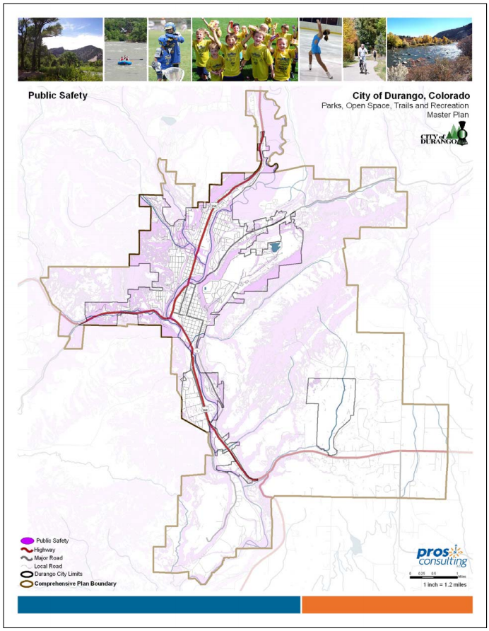
Recreation Master Plan. The plan’s “greenprinting” process uses GIS maps like this
(which shows floodplain areas in purple) to help inform decision making regarding
open space, preservation, and resource conservation.
This public safety map is an excerpt from Durango’s Parks, Open Space, Trails, and Recreation Master Plan. The plan’s “greenprinting” process uses GIS maps like this (which shows floodplain areas in purple) to help inform decision making regarding open space, preservation, and resource conservation.
“Maintain sufficient buffer to allow these high hazard landscapes to function in a natural way with minimal human intervention/modification. Recognize that these are natural processes. Allow the geomorphology of the creeks and rivers to meander naturally. For steep slopes, allow adequate separation between developed landscapes. For fire zones, provide demarcation or buffer zones between developed landscapes and natural forests.”
The protection of public safety and preservation of areas subject to natural hazards was further incorporated into Durango’s plan through a “greenprinting” process, a GIS-based tool that graphically depicts areas within the city that are deemed potentially high value and should be considered for protection. One of the key categories (or layers) used to generate greenprinting scores in this process is Public Safety, which identifies those parcels with defined flood hazards and/or steep slopes. Such parcels are representative of a priority concern that makes them more valuable in terms of protection through open space preservation and resource conservation.
Teller County adopted its Parks, Trails and Open Space (PTOS) Master Plan in 1997 to summarize the main goals, policies, standards, and facilities recommendations for parks, trails and open space that are under its jurisdiction. While an older document, it is one of the best examples of a community that has addressed hazard risk reduction in its park and open space plan.
The plan was adopted after many years of effort by the County’s Parks Advisory Board and community residents and was designed to meet the needs of the County well into the future and be actively coordinated with County growth management plans. In describing the physical setting of the County, the Plan emphasizes the flood control value of water features that “should be given a high priority to maintain as open space.” It also states that environmentally sensitive areas including wetlands, floodplains, major faults, and extreme slopes preclude most development for safety reasons as well as environmental concerns, though all may be suitable for consideration as open areas, parks, or trails. In identifying and mapping areas of open land suitable for protection, the plan establishes “Environmental Hazard Areas” as the first factor for consideration, including floodplains, areas with a slope greater than 25%, and geologic hazards such as known fault lines.
In more recent years Teller County has amplified the importance and value of risk reduction in its parks and open space planning efforts by linking them with its Multi-Hazard Mitigation Plan. For example, this includes establishing an objective to “expand…the PTOS Master Plan and implement an open space plan to protect natural resources, wildlife, wetlands, slopes, ridgelines, views, and cultural sites” and a specific policy statement to “encourage low density, nonstructural open space uses that are least subject to loss of life and property damage in flood hazard areas.”
By preparing and maintaining a parks and open space plan, communities will clearly articulate their commitment and strategy to preserving and enhancing specific assets or lands that serve multiple purposes. Primary benefits include:
- Serves as a powerful project implementation tool for hazard mitigation or avoidance – especially with regard to competing land development interests.
- Promotes multi-objective planning for parks and open space properties that intersect with hazard areas.
- Can complement and provide more robust analysis and information on parks and open space than found in the community’s comprehensive or master plan.
- Specific policy statements and pre-identified parks and open space projects that promote public safety can support more creative and competitive applications for grant funding.
- A parks and open space plan can set the policy foundation for a land acquisition and/or Transfer of Development Rights (TDR) program.
The development of parks and open space plans, as well as integrating hazard considerations into such plans, requires dedicated trained staff time or funding to hire a consultant. Other related challenges include:
- Can be challenging to implement or administer without dedicated parks planning staff.
- Some technical mapping and analysis of hazard areas may be required.
- Funding for plan implementation activities may be inadequate or difficult to obtain, particularly for the acquisition of private, developable properties.
- Plans should be updated and maintained on a regular basis, concurrent with comprehensive or master plan updates, and perhaps even more frequently for communities experiencing rapid changes through growth and land development.
- The timing of the preparation of parks and open space plans may not overlap with the development of a hazard mitigation plan. This means planners must make a concerted effort to promote coordination between the goals, policies, and actions of both efforts, as well as other related plans.
Key Facts
Administrative Capacity: Planner, parks and recreation staff
Mapping: Some technical mapping and GIS analysis may be required for integrating hazard areas and to support the supply inventory, demand assessment, or surplus/deficiency analysis
Regulatory Requirements: None required, but can support plan implementation
Maintenance: Should be updated at a regular time interval, preferably every five years
Adoption Required: Yes
Statutory Reference: N/A
Associated Costs: Staff time, plus potential costs for mapping or other technical work, public outreach activities, and consultant services
Additional Resources
Examples of the Tool
- Town of Basalt Parks, Open Space, and Trails Master Plan
- City of Colorado Springs Parks System Master Plan
- Douglas County 2030 Parks, Trails, and Open Space Master Plan
- City of Durango Parks, Open Space, Trails, and Recreation Master Plan
- Town of Erie Parks, Recreation, Open Space, and Trails Master Plan
- City of Fort Collins Natural Areas Master Plan
- Town of Frederick Parks, Open Space, and Trails Master Plan
- Jefferson County Open Space Master Plan
- Johnstown/Milliken Parks, Trails, Recreation, Open Space Master Plan
