
Soil Hazards
Erosion is the removal and simultaneous transportation of earth materials from one location to another by water, wind, waves, or moving ice. Deposition is the placing of the eroded material in a new location. All material that is eroded is later deposited in another location (Colorado Natural Hazards Mitigation Plan). In Colorado, erosion and deposition are typically initiated by water or wind.
- Riverine erosion and deposition is the process whereby river beds, banks, and floodplains are shaped by the force of moving water as it mobilizes, transports, and deposits sediments and organic debris. This process is best described as a river’s tendency for constant course alteration, shape and depth change, and the balancing act between the water’s sediment transport capacity and its sediment supply. Swiftly moving floodwaters cause rapid local erosion as the water carries away earth materials. Deposition occurs where flood waters slow down, pool or lose energy in other ways, and materials settle out. See Fluvial Hazards for more information related to the hazards associated with these natural processes.
- Wind erosion occurs when wind is responsible for land removal, movement, and deposition and most commonly occurs in exposed areas such as fields, tailings, and deserts. Another factor that controls the amount of erosion is the ease with which material can be dislodged and transported. Hard granites erode very slowly while soft silts and sands erode very quickly.
Expansive (or swelling) soils are soils or soft bedrock that increase in volume as they get wet and shrink as they dry out. Expansive soils contain a high percentage of certain kinds of clay particles that are capable of absorbing large quantities of water. Soil volume may expand 10 percent or more as the clay becomes wet, and the powerful force of expansion is capable of exerting damaging pressures on foundations, slabs, or other confining structures. Subsurface Colorado swelling soils tend to remain at constant moisture content in their natural state and are usually relatively dry at the outset of disturbance for construction on them. Exposure to natural or human-caused water sources during or after development results in swelling, and in many instances the soils do not regain their original dryness after construction, but remain moist and expanded due to the changed environment.
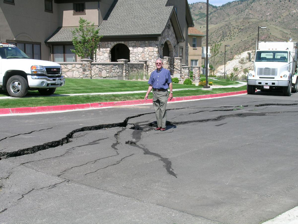
Ground subsidence is the sinking of land over man-made or natural underground voids, which can result in serious structural damage to buildings, roads, irrigation ditches, underground utilities, and pipelines. In Colorado, the type of subsidence of greatest concern is the settling of the ground over abandoned mine workings. Collapsing and settling soils are relatively low-density materials that shrink in volume when they become wet and/or are subjected to great weight such as from a building or road. Human activities that lead to subsidence include underground mining, pumping groundwater or petroleum, hydrocompaction, and draining organic soils. Natural causes of subsidence include the development of sinkholes, rock sliding downward along faults, natural sediment compaction, and melting of permafrost. Subsidence may occur virtually instantly or gradually over many years. It may occur uniformly over a wide area or as local depressions or pits separated by areas that have not visibly subsided. In Colorado, it is most common in the sedimentary rocks over abandoned coal and clay mines. Although less common, subsidence can also occur where underground water has dissolved subsurface materials or has been withdrawn by wells.
Applicable Planning Tools and Strategies
Addressing Hazards in Plans and Policies
- Comprehensive Plan
- Hazard Mitigation Plan
- Exploratory Scenario Planning
- Parks and Open Space Plan
- Pre-disaster Planning
- Resilience Planning
Improving Site Development Standards
- Stormwater Ordinance
- Site-specific Assessment
- Subdivision and Site Design Standards
- Use-specific Standards
Erosion and deposition are occurring continually at varying rates all over Colorado. Point sources of erosion are common to construction sites or other areas where human interaction with the earth results in exposed soil or removal of vegetation, and natural waterways perpetually remove and carry soil from the earth to locations downstream.
About 50 percent of Colorado’s soil has a high or very high potential for shrinking and swelling. This, coupled with the fact that most of the homes, schools, public and commercial buildings, and roads in the state are located in areas of potentially swelling clay, means that expansive soils are one of the most significant, widespread, costly, and least publicized geologic hazards in Colorado.
Subsidence and collapsible soils tend to be problematic along the Front Range, Western Slope, and in the central mountains near Eagle County. Occurrences of subsiding and collapsing soils date back to Colorado’s early history throughout these locations.
Expansive soils are one of the most significant, widespread, costly, and least publicized geologic hazards in Colorado.
Many other hazards and naturally occurring events are related to erosion and deposition. The natural flow of rivers and streams causes minor erosion and deposition, but flood events create accelerated and more dramatic erosion and deposition rates. For example, the deposition of material can block culverts or impede other engineered and natural conveyances which further aggravate flood conditions. Channel migration resulting from flooding can introduce hazard risk into new areas. Similarly, windstorm events rapidly increase the erosion and deposition of soft silts and sands in exposed areas. Landslides, mud/debris flows, and rockfalls may exacerbate the problems associated with erosion and deposition by making more material available and potentially increasing the rates of each process. Erosion and deposition issues are also exacerbated in wildfire burn areas. See Fluvial Hazards for more information about identifying where these hazards may occur in Colorado.
Expansive soils and subsidence are generally influenced by how wet or dry those types of soils become, so the climate of an area, and more specifically the seasonal precipitation/drought cycle associated with arid or semi-arid regions such as Colorado, heavily influences the occurrence and severity of these hazards.
Colorado Geological Survey
The Colorado Geological Survey is the primary source of soil hazard data specific to Colorado communities. Hazard-specific pages exist for the following hazards:
- Collapsible Soils (includes online viewer)
- Subsidence - Natural and Mines
- Expansive Soil and Rock
Colorado Water Conservation Board
The Colorado Water Conservation Board (CWCB) is the primary source of information related to Fluvial Hazard Zone mapping (although individual studies may exist in certain communities).
Natural Resources Conservation Service Colorado
The Natural Resources Conservation Service (NRCS) Colorado maintains soil surveys for Colorado. The NRCS also employs a State Conservationist that is a good contact for information about soils hazards.