
Fluvial Erosion and Deposition
Streams become hazardous when public infrastructure, houses, businesses, and other investments are placed in locations where fluvial processes naturally occur. In order to address the unrecognized hazards associated with erosion, sediment deposition and other dynamic stream processes, the CWCB has developed a program to identify and map the hazards posed by these natural stream processes and develop tools to help communities and landowners better understand the hazards associated with flood events.
The Fluvial Hazard Zone (FHZ) is defined as the area a stream has occupied in recent history, may occupy, or may physically influence as the stream stores and transports water, sediment, and debris.
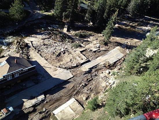
hazards (erosion, sedimentation, and debris accumulation) in the 2013
Colorado Flood. Image provided by the Town of Estes Park.
Until recently, stream and flood management has largely focused solely on water: where it is expected to move during a flood and how to avoid or mitigate flooding through engineering means. However, streams transport more than just water. Streams also gather, store, and move sediment and debris. Most of the time these processes are hardly noticeable but sometimes, especially during a flood event, erosion and deposition can happen rapidly, resulting in movement of the stream channel into new locations, bank retreat, and hill slope failures. This dynamism is innate to a stream. The resulting landscapes created by moving streams, scientists have found, have a positive impact on the ecology and function of a stream corridor through the creation of new channels, wetlands, and riparian habitats.
Historically, local governments have regulated stream corridors by relying on Federal Emergency Management Agency (FEMA) Guidance and Standards to create Flood Insurance Rate Maps (FIRMs) which are used to establish insurance premiums through the National Flood Insurance Program (NFIP). These maps are elevation-based, delineating only inundation hazards, as described on the Flood Page. These maps do not consider stream movement, the erosion of stream banks or hillslopes, or the impacts of sediment and debris deposition. As a result, properties located well above mapped floodplain elevations or outside FIRM floodplain boundaries may be affected by flood processes not accounted for in standard floodplain mapping.
Since 1978, approximately 49% of all NFIP claims in Colorado have come from policies written outside the high-risk area depicted on the FEMA FIRMs. The 2013 Colorado Front Range flood resulted in 52% of flood insurance claims originating outside of regulatory floodplains demonstrating that reliance on flood inundation maps alone does not provide a complete picture of flood hazards.
Fluvial Hazard Zone mapping represents a significant and necessary step forward in identifying and addressing hazards posed by flood events. Flood hazard reduction, in the long-term, will be measured primarily by our ability to solve problems at the watershed and stream corridor scale, and secondarily by how we resolve conflicts at individual sites. From a planning standpoint, this means communities should recognize that streams are naturally dynamic systems prone to move and that sediment and debris should be accounted for when decisions are made.
Because streams and waterways do not follow political boundaries, preparation for flood-related fluvial hazards requires individual, local, regional, state and federal partnerships that can work across jurisdictional boundaries in watersheds to identify these areas and develop management policies that reduce long-term threats to life and property.


All streams are dynamic, and when floods occur or after wildfires burn their watersheds, they are prone to dramatically alter their size, shape and location. If not properly planned for, these natural processes of erosion and deposition can cause considerable damage to infrastructure, agriculture, and residential property as well as endanger lives.
In order to better understand, plan for, and communicate fluvial hazards, some Colorado communities are choosing to map the Fluvial Hazard Zone (FHZ) - the area a stream has occupied in recent history, may occupy, or may physically influence as it stores and transports water, sediment, and debris. FHZs are mapped primarily by fluvial geomorphologists through the interpretation of topographic, geologic, and geomorphic information (i.e., data that describes the physical location, form, and active sediment and debris transport processes of a riverine system).
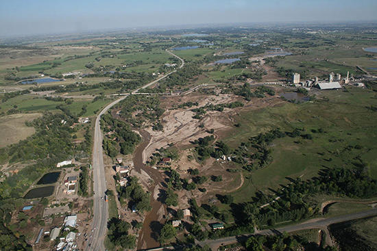
shifted its location during the 2013 Colorado Flood.
Photo provided by the City of Longmont.
Fluvial Hazard Zone mapping captures hazards stemming from stream movement, the erosion of stream banks or hillslopes, and the impacts of sediment and debris deposition. Unlike standard floodplain mapping, Fluvial Hazard Zone mapping assumes that the ground beneath or adjacent to floodwaters is going to change either incrementally or dramatically as the area is exposed to energy, water, sediment, and debris during a flood.
Fluvial Hazard Zone mapping is not directly tied to hydrologic statistics, specific storms, or runoff events and is not associated with a probability of occurrence. FHZ maps may not identify areas susceptible to standing water or very low energy flowing or pooling water, or groundwater upwelling or seepage.
FHZ mapping can be used for a multitude of purposes but any decisions for regulation are made at a local, not state or federal, level. FHZ maps also do not impact flood insurance rates or premiums. CWCB provides information on how communities can incorporate FHZ maps into their planning in a Quickstart Guide. Additionally, while the process of identifying fluvial geomorphic hazards on a map may be a new endeavor, the mapping does not introduce a new hazard to a community or landowner.
Why Not “Erosion Hazard Mapping”?
Erosion is just one of the geomorphic hazards associated with streams. Simply measuring, modeling, or calculating erosion or bank retreat is insufficient in capturing all hazards in a stream corridor. Other geomorphic hazards include deposition of sediments, channel avulsions, fan processes, and slope failures of adjacent hillslopes as streams cut into their valley margins. This program identifies areas susceptible to erosion but also includes areas where these other fluvial geomorphic hazards exist.
While fluvial hazards are most frequently triggered by rainfall associated with sustained wet weather and/or severe thunderstorms, they may also be caused or exacerbated by wildfires, debris flows and landslides, ice jams, or rapid melting and runoff following severe winter storms. In the 2013 Colorado floods, a major cause of flood damage was debris that clogged up bridges and culverts. Another major issue in 2013 was waterways carving entirely new channels, meaning risk had not been conveyed on existing maps. Fluvial Hazard Zone maps attempt to identify potential risk associated with fluvial processes such as channel migration, streambank erosion, and sediment and debris deposition.
Flooding is one of the three central components (along with drought and wildfire) of a complex system of interrelated natural hazards that are fundamentally tied to Colorado’s continental semi-arid climate. Drought conditions may lead to soil compaction, and wildfires may leave slopes denuded and hydrophobic (unable to absorb water). In these cases a single heavy rain event can lead to higher volumes of runoff and a correspondingly higher risk for fluvial processes of erosion and sedimentation.
In addition to the direct impacts a flood event hazard may cause, it can also trigger multiple cascading hazard events. Rising floodwaters may cause the failure of a dam, levee, or other impoundment structure resulting in the rapid inundation of locations outside of mapped special flood hazard areas.
Community planners should begin assessing fluvial hazards by coordinating with their local floodplain administrator, along with the appropriate staff at the Colorado Water Conservation Board (CWCB), on the identification of the best currently available data and tools for assessing fluvial hazard risk, as well as the status of any updates or possible enhancements to those resources.
Communities with GIS resources available to support their planning efforts will be able to conduct more rapid and robust risk assessments, including overlay analysis, to quantify the exposure of people, parcels, buildings, critical facilities, and other community assets that are within Fluvial Hazard Zones (FHZ). In some cases, communities may have on-the-ground information such as, public works records of roads and bridges that consistently have issues in flood events.
The delineation and updating of Fluvial Hazard Zone maps is generally performed by private consulting firms under contract with CWCB, which administers the State’s Fluvial Hazard Mapping Program. Based on strict guidelines, Fluvial Hazard Zone maps are created through the use of topographic, geomorphic, geologic, hydrologic, hydraulic, and biotic analyses.
Communities that are interested in adding fluvial hazard maps into their floodplain planning should coordinate closely with the CWCB. Fluvial Hazard Maps should be cheaper to produce than FEMA floodplain maps and may provide multiple additional benefits to a community.