Colorado Geological Survey
The Colorado Geological Survey is the primary agency for maintaining Colorado earthquake hazard information.
- The CGS Earthquake page is a one-stop location for finding more information on Colorado earthquakes.
- The Earthquake Reference Collection is a listing of over 500 earthquakes and faulting events that have taken place in Colorado.
- The Colorado Earthquake and Late Cenozoic Fault and Fold Map Server is an online map viewer that indicates where fault lines and folds can be found in Colorado.
Unites States Geological Survey
The United States Geological Survey (USGS) is the primary federal government agency for providing information on earthquakes.
- The USGS National Seismic Hazards Map is a national standard for identifying earthquake hazard zones.
- USGS also maintains a site dedicated to Colorado Earthquake Information.
National Earthquake Hazards Reduction Program
The National Earthquake Hazards Reduction Program (NEHRP) is the federal government’s coordinated long-term nationwide program to reduce risks to life and property in the U.S. resulting from earthquakes.
Federal Emergency Management Agency (FEMA)
FEMA maintains a resource website that provides useful information regarding earthquakes.
Additionally, FEMA's Hazus is available for estimating vulnerability due to earthquakes. Hazus is a nationally applicable standardized methodology that contains models for estimating potential losses from earthquakes, floods, and hurricanes. Hazus uses Geographic Information Systems (GIS) technology to estimate physical, economic, and social impacts of disasters. It is a loss estimation tool, but is not predictive. It graphically illustrates the limits of identified high-risk locations due to earthquakes, hurricanes, and floods. Users can then visualize the spatial relationships between populations and other more permanently fixed geographic assets or resources for the specific hazard being modeled, a crucial function in the pre-disaster planning process.
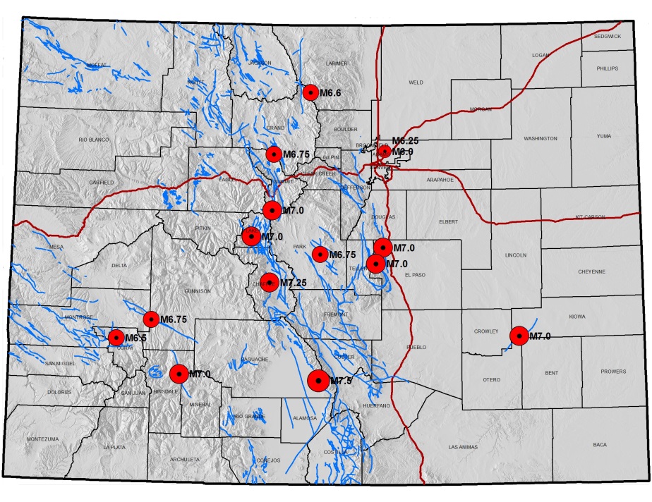
The Colorado Geological Survey utilized Hazus to determine the potential locations and impacts of various magnitude earthquakes on faults across Colorado. Hazus summary reports on potential losses may be downloaded for both statewide scenarios as well as for individual counties.
The CGS Interactive Hazus Events Map details epicenters of possible future seismic events based on Maximum Credible Earthquakes (MCE) that have been assigned to specific faults by various entities. Each of the event locations have been analyzed using FEMA Hazus software and correspond to statewide reports on potential loss and damage.The CGS Interactive Hazus Events Map details epicenters of possible future seismic events based on Maximum Credible Earthquakes (MCE) that have been assigned to specific faults by various entities. Each of the event locations have been analyzed using FEMA Hazus software and correspond to statewide reports on potential loss and damage.
Colorado Earthquake Hazard Mitigation Council
The Colorado Earthquake Hazard Mitigation Council (CEHMC) is a multi-disciplinary organization that is interested in developing a better understanding of earthquake hazards in Colorado. The group meets monthly and has been in existence in various forms for more than three decades.
Applicable Planning Tools and Strategies
Addressing Hazards in Plans and Policies
- Comprehensive Plan
- Exploratory Scenario Planning
- Hazard Mitigation Plan
- Pre-disaster Planning
- Resilience Planning
Protecting Sensitive Areas
Improving Site Development Standards
Improving Buildings and Infrastructure
Enhancing Administration and Procedures

