Colorado communities are impacted by flooding on an annual basis, and nearly every community in the state is subject to special flood hazard areas as mapped by FEMA and as made available through the Colorado Water Conservation Board. In addition, there are approximately 677 state-regulated dams that, in the event of a failure, could cause loss of life and/or significant property damage in communities located within downstream flood hazard areas.
The most flash-flood prone regions of Colorado are found along the base of the lower foothills east of the mountains. Several extreme floods such as the infamous Big Thompson Canyon flood of July 31, 1976, have occurred in this vulnerable area. Flash floods occur on the Western Slope as well, but with typically lower frequency and intensity due to a reduced supply of moisture to fuel such storms (Colorado Climate Center, 2015).
Flood hazards pose major risks to property and human life and have caused some of the largest disasters in Colorado history in terms of financial costs and casualties. Between 20 to 30 large-magnitude floods occur somewhere in the state every year, and major flood disasters (warranting a federal disaster declaration) have occurred on average every five years since 1959. The South Platte River floods of 1965 and the 2013 floods in the Front Range and northeast counties caused multiple deaths and nearly $3 billion and $4 billion in total estimated damage in current terms, respectively. The Big Thompson River flood of 1976 caused 144 deaths. Floods can cause billions of dollars of property and infrastructure damage, resulting in significant economic impacts for directly affected communities and for the state as a whole (Colorado Resiliency Framework, 2015, p. 3-4).

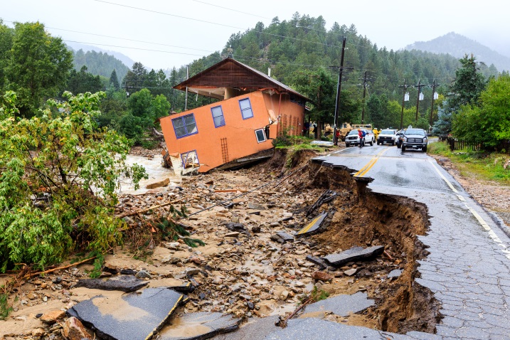
The September 2013 flood disaster caused major damage to private property and public infrastructure across the Front Range of Colorado. Source - Federal Emergency Management Agency. Colorado Town Isolated. May 1, 2014. Photo by Steve Sumwalt.
Applicable Planning Tools and Strategies
Addressing Hazards in Plans and Policies
- Comprehensive Plan
- Climate Plan
- Exploratory Scenario Planning
- Hazard Mitigation Plan
- Parks and Open Space Plan
- Pre-disaster Planning
- Resilience Planning
Strengthening Incentives
- Community Rating System
- Development Agreement
- Density Bonus
- Transfer of Development Rights
Protecting Sensitive Areas
- 1041 Regulations
- Cluster Subdivision
- Conservation Easement
- Fluvial Hazard Zones
- Land Acquisition
- Overlay Zoning
- Stream Buffers and Setbacks
Improving Site Development Standards
- Stormwater Ordinance
- Site-specific Assessment
- Subdivision and Site Design Standards
- Use-specific Standards
Improving Buildings and Infrastructure
- Building Code
- Critical Infrastructure Protection
Enhancing Administration and Procedures
- Application Submittal Requirements
- Community Engagement
- Funding for Mitigation Strategies
- Post-disaster Building Moratorium
